.png)
92.7 The Wave unveiled the POWER MAX DOPPLER RADAR in March of 2008. In a few weeks tornadoes would move through Clinton and Wayne County leaving a path of destruction, luckily no one was injured.
POWER MAX DOPPLER RADAR is live radar, meaning what we see is what's happening after the radar antenna makes its sweep. This provides greater warning time when severe storms roll through.
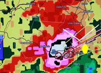
Below are examples of POWER MAX DOPPLER RADAR (top) and someone elses radar (bottom). It shows how live radar gives an advantage in warning people about severe weather.
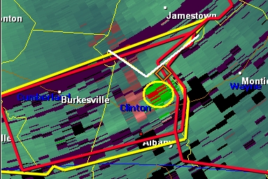
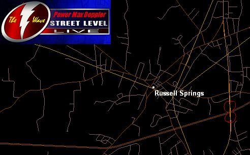
The above image at 12:44 PM shows rotation NE of Albany near the Wayne County line. The tornado is in the yellow circle. Please note, the white notch is the extreme southern tip of Russell County at Rowena, Wolf Creek Dam and Creelsboro.
********************************************
Below, someone elses radar at the same time shows rotation well to the west of where the tornado actually was. The white notch here is the same area denoting the extreme southern tip of Russell County. The bright yellow spot shows where POWER MAX DOPPLER was indicating the tornadic activity.
--------------------------------------------------------------------------------
Here are some other advantages of POWER MAX DOPPLER RADAR....
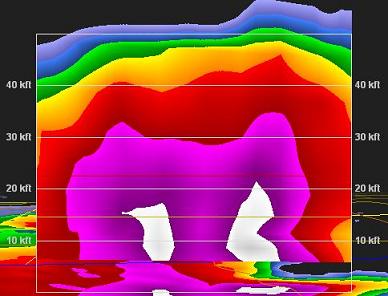
Slice inside the storm to see cloud tops, hail and much more. In this storm, pink and whites are signs of large hail.
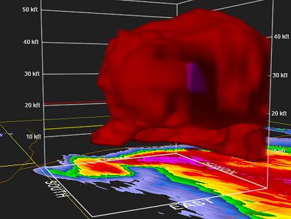
3-D Technology allows us to actually see a tornado on the ground in some situations. Note the purple inside the storm indicating hail.
With street level capabilities, we can know exactly what's happening in your community.
When we move our mouse over the road/street, the name appears.

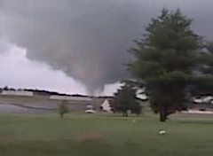
Adiar County tornado June 9th 2010
Photos by Perry Parrish
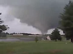
...NATIONAL WEATHER SERVICE CONFIRMS AN EF-0 TORNADO IN CENTRAL
ADAIR COUNTY NEAR COLUMBIA ON JUN 9 2010...

A STORM DAMAGE SURVEY TEAM FROM THE NATIONAL WEATHER SERVICE IN
LOUISVILLE CONFIRMED AN EF-0 TORNADO TOUCHED DOWN IN CENTRAL ADAIR
COUNTY ON WEDNESDAY EVENING...JUN 9 2010.

BASED ON THE SURVEY AND INTERVIEWS WITH RESIDENTS IN THE AREA...AN
EF-0 TORNADO BRIEFLY TOUCHED DOWN 2.6 MILES WEST OF COLUMBIA JUST
SOUTH OF HIGHWAY 61. A BARN WITH 2 HORSES INSIDE WAS DESTROYED BUT
THE HORSES WERE NOT HURT. NUMEROUS TREES WERE DOWNED ALONG THE BRIEF
2 MINUTE LENGTH/PATH OF THE TORNADO WITH ONE TREE PARTIALLY UPROOTED
ON A GARAGE AS THE TORNADO DISSIPATED ABOUT 2 MILES WEST OF
COLUMBIA.

THE DAMAGE TO THE BARN AND THE SIZE OF THE DOWNED TREES WERE
CONSISTENT WITH EF-0 TORNADO DAMAGE WITH WINDS ESTIMATED TO BE IN
THE 80-83 MPH RANGE. THE TOTAL LENGTH OF THE TORNADO WAS
APPROXIMATELY 2/3 OF A MILE WITH A WIDTH OF 40 YARDS.

SUMMARY...

TIME...APPROXIMATELY 610 PM CDT/710 PM EDT
TOUCHDOWN...2.6 MILES WEST OF COLUMBIA NEAR HIGHWAY 61.
DISSIPATION...2 MILES WEST OF COLUMBIA AT 612 PM CDT.
EF-SCALE RATING...EF-0
ESTIMATED MAX WINDS...80 TO 83 MPH.
PATH LENGTH...2/3 MILE
PATH WIDTH...40 YARDS
INJURIES...NONE
FATALITIES...NONE
Destroyed Barn

Large Tree on Garage

Tornado Path

LISTEN LIVE TO 92.7 THE WAVE FOR SEVERE WEATHER UPDATES...
![]()
![]()
![]()
![]()
© 2024 WHVE, Shoreline Communications
Built on Envisionwise Technology.

